
Geology of the Hawaiian Islands
Story of the origins, the past, the present and the future of Hawaii
by Marcin Smok

The Hawaiian archipelago is a very unique landmass on planet Earth. A magnet for geologists, volcanologists, botanists and countless other scientists, this chain of volcanic islands in the middle of the Pacific Ocean has always been a place of wonder, that for the longest remined an unanswered question in the history of our planet. Discoveries made here helped us understand the geological processes that shaped and continue shaping Earth. Processes that dwarf our very existence and reminds us that humanity's rule over the globe is nothing but temporary, a mere footnote in the story of the blue planet.
To understand how Hawaiian Islands were created is to learn about the land forming mechanism our planet implements from the dawn of time, the most fundamental and violent of all Earth's forces- the power of a n erupting volcano. Before we go back in time to when Hawaiian island started forming, let's fast forward to present day and summarize what we know about them from one quick glimpse at the map...
The Hawaiian Archipelago
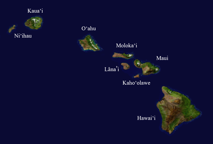
Satellite composition of the Hawaiian island chain. by NASA/Goddard Space Flight Center
Hawaii, a chain of volcanic islands situated in the middle of the Pacific Ocean, is the most isolated archipelago on Earth. It remained untouched by humans for thousands of years, discovered only a mere millennium and a half ago by mighty Polynesian sailors searching for a new place to expand their civilization. The closest landmass is Kiritimati atoll, at over 1300 miles to the south, while the nearest continent lays 2400 miles away to the east, where a straight line ends at the beach in California. The island chain consists of eight major islands- at its northernmost tip lays Ni'ihau and Kauai, then O'ahu with the state's capitol Honolulu, followed by the group of four islands- Maui, Lānaʻi, Moloka’i and the uninhabited Kaho'olawe, and finally, at its southern end, the largest and youngest- the island of Hawai'i, commonly known as the Big Island. Each of the eight tropical islands is different from another in terms of geological features, climate zones, volcanic activity and other factors. When scientists first discovered the uniqueness of each individual island in the chain, they ultimately knew Hawaii would be a perfect place to study the Earth's origins. What they've learned through decades of observations and collection of scientific data revolutionized Earth sciences and laid foundation for a number of fundamental theories, like plate tectonics, hot spot and mantle plumes… but let’s not get in over our heads, I’ll explain each later.
Hawai'i always played the role of the most intriguing to scientists island in the chain, simply because it has something other islands lack- erupting volcanoes. The enormous Mauna Loa erupted in regular intervals for more than 200 years (the last documented eruption occurred in 1780), with latest taking place in 1984, meanwhile Big Island's youngest volcano, Kilauea, spills lava continuously since its formation, which is estimated to be between 300,000 to 600,000 years ago!!! The latest lava flow from Kilauea's vent Pu'u 'O'o started in 1983 and continues to this day.
The enormous Mauna Loa volcano as seen from the slopes of Mauna Kea.
Scientists in the 19th and early 20th century tried to answer questions of the volcano's role in island-building and the origins of magma that surfaced in this remote location. The breakthrough came with the invention of gravimeter by a Dutch geophysicist and geodesist Felix Andries Vening Meinesz. His ingenious apparatus allowed for precise measurement of Earth's gravitational forces, which in turn enabled to determine a given landmass’s size. He took his device to the Big Island and his calculations shocked the scientific community- what was visible above the ocean surface was only a tip of an enormous, incredibly massive mountain- when measured from the ocean floor, Hawai'i tallest peak, Mauna Kea summit, reach 33,100 ft. (10,100 m) in height, making it the tallest mountain on Earth (almost twice the size of Mount Everest in the Himalayas). Besides that, Mauna Loa, Hawai'i largest volcano by area and volume, is so massive it bends the Earth's crust towards the mantle, making it the heaviest single mountain on the planet. The numbers are so large it is beyond imagination how much lava spilled from planet's interior to form the island. To give a point of reference, geologists found a method to measure the amount of lava that is currently produced by Kilauea and the amount is staggering- as much as 100 million cubic yards (around 76,500,000 cubic meters or 76.5 billion liters) of liquid rock surfaces on Big Island every year. According to my calculations, that would be 640 gallons (2423 liters) of glowing red lava per second!!! Some of it flows on the surface, but the majority gets to its final destination- the ocean- through a "volcano plumbing system", a system of underground tunnels called lava tubes. A lava tube forms when a top layer of surface flowing lava hardens and forms a thick, solid cap that enables the still liquid lava beneath to travel longer distances without ‘crusting over” ( OK I made up that term, don’t reference me). A great example of an accessible lava tube is the Thurston Lava Tube in Volcanoes National Park on the island of Hawai'i.
Lava from Kilauea volcano By Hawaii Volcano Observatory (DAS) [Public domain]
Flowing lava is an extremely powerful natural occurrence. I’ve seen it with my own eyes and the only way I can describe it is it’s a slow-motion (not everywhere though) river of liquid fire devouring everything on its path and leaving a permanent dark scar on the landscape. However powerful it might be, Kilauea volcano's lava meets its match when the land ends- a fierce battle of fire and water always ends with the same outcome. From a cloud of water vapor and toxic mix of carbon dioxide, sulfur dioxide, hydrogen sulfide and other gases, a new land emerges. Solidified lava forms a new patch of the island, just like it did for eons of time before. Just to give you a perspective of how amazing the land-forming ability lava possesses, for the last 20 years eruption from Kilauea vent Pu'u 'O'o created 540 acres (219 hectares) of new ground (excluding the recent significant eruption in 2018). That would be a little over 408 American football fields of knife-sharp, jet black rock.
Seeing a river of lava entering the ocean with her/his own eyes, a person would assume that this process is the sole source of the formation of Big Island. Scientists, using a method of calculating lava rocks' age called radiocarbon dating, found out that the island of Hawai'i is about 400,000 years old. That might seem long from a human lifespan perspective, but through a geological lens, Big Island is a newborn. The five volcanoes- the active Kilauea and Mauna Loa, dormant Mauna Kea and Hualālai, as well as extinct Kohala- make up what today is the biggest island in the chain (it is so large all the other major Hawaiian Island could fit into it and there still would be some room to spare). Or, as you may have heard before, it’s bigger than Connecticut. I don’t know why it always gets compared to this forested state in New England, but for some reason, it does.
When people realized the island of Hawai’i is essentially one huge lava field with volcanoes looming over the landscape, they've compared this knowledge to other islands in the archipelago. Each of the 8 major island yield evidence of a volcanic past, yet they are so dissimilar to one another, it's hard to believe they all formed the same way. Besides that, while all Hawaiian islands have volcanic origins, only Big Island has active volcanoes. These confronting facts had scientists scratching their heads. Something was missing in the theory of the archipelago's past...
Plate Tectonics

Felix Andries Vening Meinesz By Woodwalker at en.wikipedia
To continue with the story, we have to return to Mister Felix Meinesz and his gravimeter. The instrument was used to measure gravity at sea level and below the ocean surface, so when Meinesz took measurements aboard submarines, he found some gravity anomalies at the ocean floor. He attributed these anomalies to prove a theory formed earlier in 1912 by German geophysics Alfred Lothar Wegener, called "continental drift". The hypothesis Wegener put forward posited that continents move about each other, "drifting" on the ocean floor. His idea, albeit uncompleted, sparked a race to find solid evidence of continental movement. The next piece of the puzzle was delivered with the technological advancements brought by World War I Theater. The invention of sonar enabled the military to draw a virtual map of the ocean floor. Results of these surveys were shocking- instead of a vast, flat plain, as was believed before, the bottom of the seas is full of features, just like on continents it surrounds- valleys, canyons, and even enormous mountain ranges are all present below the surface. The most interesting find emerged in form of undersea ridges that run parallel to continents' coasts. We now call them mid-ocean ridges. Knowing that coincidence is not something our planet’s good at, more and more scientists agreed that continents move. The ultimate evidence, however, was still missing.
The mid-ocean ridges puzzled geologists until an American ocean geologist Harry Hess proposed a theory stating that under these ridges hot magma rose closer to the surface, pushing the ocean floor apart, hence the continental movement. His hypothesis began to make broader sense when US Navy published a report of seafloor magnetism they've prepared during the Second World War. They've found that basalt rocks (basalt is a type of lava that is abundant on the ocean floor) have magnetic minerals in them that are "locked” with the alignment of Earth's magnetic field. Interestingly, these magnetic rocks showed that Earth's magnetic field reversed its polarity (magnetic north flipped and became magnetic south and vice versa) many times during the past. Scientists took this new knowledge to a Mid- Atlantic ridge and made a remarkable finding- at the crest (the area center of the ridge), the polarity was normal (same as now), but moving away in either direction, they've found rocks with reversed polarity at approximately the same distance from the crest. That proved the theory of magma pushing the ocean bottom away and creating new seafloor as it cools down. They named these places divergent boundaries. Continued research yielded another discovery- there are also places called subduction zones, where the ocean floor seems to be sinking down to the Earth's interior, one part of the crust sliding under the other. Those places are called converged boundaries. The third type of boundary was discovered later and called transform-fault boundaries, where two plates are sliding horizontally past one another (this kind of plate boundary is responsible for earthquakes in California, for example). The outcome of this research can be seen in the below picture:
Global tectonic activity of the Earth . Picture by NASA
A map of the world, complete with mid-ocean ridges and subduction zones. The visualization of these ocean features formed a revolutionary theory, a discovery that changed geology forever and helped to understand how our planet changed in the past, explained how many of the natural features on land came to be, and gave a clue about the origin of earthquakes and volcano eruptions.
The theory of plate tectonics is widely accepted to be the best model of our planet's geology. According to its principles, the Earth's crust (our planet's outer, solid layer) is broken up into pieces called tectonic plates. There are 8 major and several smaller tectonic plates in the world and they all seem to "drift" or "slide" on Earth's next layer, the upper mantle. The constant movement of tectonic plates re-shaped the size and amount of continents our planet had in the past but also created some of the most amazing natural wonders we admire this day. The creation of the Himalayas, for example, happened when the ancient Indian continent, drifting north as part of the Indo-Australian Plate, collided with the Eurasian plate. The "forehead" of the Indo-Australian plate, in form of the ocean crust, got uplifted, turning into a new mountain range- Himalayas. You can find fossils of ancient marine creatures high in these mountains today, no kidding, Google it. The same kind of plate collision remnants can be found all over the world. If you are looking at a spectacular, covered in-glacial ice mountain range, there’s a very good chance it came about as a result of plate tectonics.
Another effect of plate boundaries interaction are frequent earthquakes (when plates slide against each other, sometimes the energy absorbed by the rocks reach a certain point where it can no longer be contained, the rock fractures and all that energy is released in a form of seismic waves manifesting as earthquakes on the surface of our planet. It is called the elastic rebound theory if someone is interested). In addition to that, plate boundaries are regions of intensive volcanic activity. In fact, when geologists mapped the most active volcanoes on Earth, it turned out most of them follow plate boundaries. A string of 452 volcanoes, oceanic trenches, volcanic arcs, and volcanic belts form a horseshoe-shaped line extending from the Pacific coasts of South and North Americas, north to Bering Strait, and then south around the coast of Japan, Philippines, Indonesia and other South Pacific islands, reaching the southern tip of New Zealand. This imaginary line is called the Pacific Ring of Fire and it encompasses the most seismically and volcanically active regions in the world. An impressive 75% of the planet's most active volcanoes lays on the Ring of Fire. The terrains along the line are also epicenters of 90% of all earthquakes occurring around the globe. The discovery of the Pacific Ring of Fire and its relationship to plate tectonics brought answers to centuries’ old questions about volcanism and the destructive force of earthquakes. This new knowledge applied to the vast majority of regions with high volcanic activity, but one place was different...
Pacific Ring of Fire Image by USGS
Hawaii lays right in the middle of the Pacific plate, thousands of miles from the nearest boundary. There is no crack in Earth's crust through which lava could come up to the surface. Knowing that the theory of plate tectonics is likely correct, Hawaii's volcanic origins remained a mystery. Scientists had to turn somewhere else for clues. Once again, American Navy came with a possible solution when they've mapped the seafloor north of Hawaii with sonar. The result revealed a chain of seamounts, underwater mountains made of volcanic rock that stretches for 3,105 miles (4,997 km), all the way to Aleutian Trench off the coast of Alaska. Besides seamounts, the chain also contains numerous islands, atolls, and reefs. The southern part of the chain consists of the Hawaiian Island themselves, followed by the Northwestern Hawaiian Islands (also called the Leeward Isles) and in its northern boundaries, a seamount range called the Emperor Seamounts. Together, they form the Hawaiian-Emperor seamount chain, one of the longest on the planet. What is even more interesting about them, though, is that when you look at a 3-D model of the seafloor, seamounts and islands of the Hawaiian-Emperor chain form two, straight lines. No other seamount range is aligned with that level of geometrical precision.
Hot Spot
Hawaiian-Emperor Seamount Range By Ingo Wölbern (own work, created with GMT Software) [Public domain], via Wikimedia Commons
The existence of Hawaiian-Emperor seamount range made the case of Hawaii origins even more complicated. Scientific community could not produce a valuable argument until a Canadian geophysicist and geologist John Tuzo Wilson proposed an unorthodox idea, basing his thoughts mainly on a simple observation- looking at the geological features of the major Hawaiian Islands, Wilson found that the more north the island was situated, the older it appeared to be (more erosion features, more vegetation). He was especially fascinated by the extensive erosion on the island of Kauai, with its dramatic Na Pali coast, a lush tropical jungle of its interior and a deep ravine that runs through the island- the Waimea Canyon. Radiocarbon dating validated Wilson's assumptions- each following island, starting with Hawaii and going north, was older than the previous. It is now estimated that Big Island is 400,000 years old, Maui from 1.3 million (West Maui) to 750,000 years old (Haleakala), Oahu around 3 to 4 million years old and the oldest, Kauai, dated at 6 million years old. However, continuing to date the other formations in Hawaiian-Emperor seamount chain and ending at its northernmost underwater mountain- Meiji Seamount- its estimated age is astonishing 82 million years old. The two very unique occurrences (sequentially rising age of islands and the straight lines that form the Hawaiian- Emperor Seamount chain) led Wilson to formulate an incredibly interesting idea- the theory of a hot spot. Wilson proposed that under the Pacific tectonic plate lays a region of extremely hot magma, which rises through a system of canals within the lithosphere and surfaces at the ocean bottom, slowly forming an island. The volcanic activity continues for around a million years and then fades out as the island drifts away from the fixed hot spot with a tectonic plate it sits on. If this theory would prove to be true, the southeastern tip of Big Island is currently in the epicenter of the hot spot.

Kamila holding sand that contains olivine
John Tuzo Wilson's theory of a hot spot was not only brilliant but also highly believable, because it provided answers to the previously unsolvable case of Hawaiian Islands geology. On the other hand, it also came with a new set of problems- what is a hot spot? How did it form? Why does it stay in the same place for millennia? An American geophysicist named William Jason Morgan proposed an answer to at least some of these questions by presenting a theory of mantle plumes. A mantle plume is "a posited thermal abnormality where hot rock nucleates at the core-mantle boundary and rises through the Earth's mantle becoming a diapir in the Earth's crust"-source Wikipedia. In plain English, a mantle plume is sort of like a lava lamp, where a heavier liquid absorbs heat from a light bulb (in this case the Earth’s outer core), expands and rises to the top of the lamp (crust-mantle boundary). The magma that rises to the Earth's crust from the core-mantle boundary forms a dome under the crust and releases the pressure through a narrow "tunnel"- a hot spot. To find proof of the mantle plume hypothesis, scientists literally cracked open lava rocks to examine their mineral content. They've soon found what they were looking for, locked in a lava rock sample from the island of Hawai’i -a mineral called olivine. This dark green mineral is known to originate deep inside our planet and seeing it on the surface validated Morgan's theory. To see olivine yourself, head to Papakōlea Green Sand Beach on Big Island.
The theory of a hotspot not only explained how the island chain has formed but also provided the ultimate proof of plate tectonics. Today, the network of sensors allocated throughout the world is monitored by satellites using the GPS system, allowing for precise measurements of continental plates’ movement. The image below shows the direction of these minute changes in plate dynamics. The alignment of the Hawaiian Islands corresponds to the movement of the Pacific Plate, which drifts in the northwest direction at a speed of between 2-4 inches (5-10 cm) per year. Once the hot spot hypothesis was widely accepted to be a reasonable explanation of Hawaiian island formations, scientists started looking for other island chains that might have been formed in the same way. We are almost certain that the Galapagos island chain, a portion of Iceland, and some islands in the Indo-Pacific region, were all created by a hot spot.

Plate tectonic movements measured by GPS devices. Image by NASA
With Hawaii origins explained, a set of new questions arose: What happened to the older islands in the chain? What is the future of Hawaii? What happens when Big Island moves out of the hot spot? For answers to those and other questions about Hawaii archipelago geology, we need to go back to sea floor mapping...
The Fate of an Island

Aerial photo of Nihoa island. By George H. Balazs, NOAA
Magma, in form of a mantle plume that accumulates below Hawaii, generates an extreme pressure on Earth's crust- the map of the seafloor around the island chain shows that the crust is bowed upward around 500 feet from the surrounding seafloor, creating a gently sloped underwater hill. As the islands move away from the hot spot, they slide off this "hill", slowly sinking into the ocean. It is estimated that Kauai, the oldest of the major Hawaiian Islands, will be reduced to a mere rock sticking out from the Pacific Ocean, resembling the current state of Nihoa, the tallest island of the Northwestern Hawaiian Islands, located 140 miles (240 km) from Kauai.
Plate tectonics is not the only cause the Hawaiian Islands disappear. The archipelago is constantly “eaten away” by wind and water erosion. One look at the landscape of Kauai reveals the sheer power of erosion that takes place there- geological features like Waimea canyon or Na Pali coastline make an impression of an island made out of limestone that’s dissolving rapidly. That would surely make sense, only if the entire island wasn't made out of one of the hardest rocks on Earth- tholeiitic basalt. How could water do so much damage in so little time (from a geological perspective, naturally)?
As hard as tholeiitic basalt may be, it has one flaw- high iron concentration in its structure. On the other hand, Kauai owes its amazing greenery to the high annual rainfall (in fact, Mount Wai-‘ale-‘ale is the wettest spot on Earth with 450 inches (11,430 mm) of rainfall annually). Combine the two and tholeiitic basalt flaw becomes its nemesis- the rock literally rusts away when it's wet. The incredibly beautiful red color of Kauai mountains and canyons is due to the oxidization of iron present in ancient basalt lava. When the rock "rusts", it becomes soft to the point where it breaks easily when handled. This erosion process slowly dissolves the Hawaiian Islands one by one, until their ghostly remains are swallowed by the Pacific Ocean. This phenomenon can be observed on every island in the chain- the Big Island's Waipi'o Valley is in the initial phase of cliff erosion, while Maui's Olowalu Valley shows a more severe weathering.
Iao Valley on the island of Maui. From our 2013 trip
A closer study of Moloka’i resulted in yet another island-shaping event. In the late 1980s, vastly improved sonar technology allowed for creating a detailed map of the ocean floor. United States Geological Survey mapped the area around Hawaii using Gloria side-scan sonar, an aperture designed specifically for sea topography scanning. They've found a large accumulation of undersea boulders 200 miles north of Moloka’i. When geologists started measuring these pieces and took rock samples to find out where they originated, the outcome turned out to be quite shocking- the debris scattered on the ocean floor, if put back together, fit like a jigsaw puzzle back into Moloka’i north shore. Radiocarbon dating estimated the rock samples to be 1.5 million years old and consist of exactly the same element composition as rocks on the island. There is no doubt a cataclysmic landslide occurred on Molokai- virtually half of the island slid into the ocean at once in an event lasting perhaps only a few minutes. The resulting- mega tsunami (think Interstellar when they land on the water planet- like that), with waves that could have reached 1,000 feet (300 meters) in height, swept through the Hawaiian islands and reached as far as the coast of Australia to the west and US Pacific coast to the east. The aftermath of this natural disaster left Moloka’i with a new coastline, its cliffs reaching 3013 ft. (1010m), the highest in the world. Later research confirmed that landslides occurred many times on the Hawaiian Islands, the most recent of which happening around 100,000 years ago. These landslides occur because the land sits on unstable, sandy surface layers sandwiched between volcanic rock. When fresh lava flow reaches the ocean, it solidifies on a sandy beach, a weathered lava rock from past eruptions. The new land, sitting directly on top of these weak foundations is prone to give away and slide into the ocean. It puzzles me why Hollywood didn’t think of that yet.
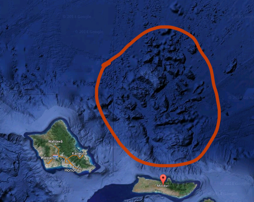
Debris field from Molokai and Oahu landslides. Image from Google Earth
Hawaii landslides are a real threat not only to the archipelago but also to the entire Pacific Northwest, New Zealand and New South Wales. Particularly alarming is the current condition of part of the island of Hawaii called the Hilina slump. This chunk of land, 5,000 cubic miles (20,000 km³) in size, located in Kilauea east rift zone, is literally breaking away from the rest of the volcano and sliding towards the ocean at a rate of 4 inches (10 cm) a year. This displacement can (and did in the past) create earthquakes and it is not ruled out that this massive chunk of land can suddenly slip at a much faster pace. If that would happen, the outcome would be catastrophic to millions of people living near the Pacific coast. Scientists take this threat seriously and the many faults created by Hilina slump displacement are closely monitored and studied.
Through the amazing work of scientists from all over the world, we discovered how the Hawaiian Islands came to be and what forces shaped them. We also learned that the chain's ultimate fate lays in the depths of the Pacific Ocean. One remaining question still awaiting answer is- What's next? We know Kauai will most likely disappear completely in 1-1.5 million years, Oahu will take place as the oldest Hawaiian island, Maui will continue to reshape its landscape (with Haleakala giving it’s last show of bursting lava before losing its connection to the hot spot) and Big Island volcanoes will eventually finish their eruptive phase. What will happen when Kilauea moves away from the hot spot? The answer: it will be time for Lōʻihi to shine...
Lōʻihi, the birthplace of an island

Pillow lava from Loihi volcano, Public domain photograph by A. Malahoff, University of Hawaii, 1980. Figure 6.8-C, U.S. Geological Survey Professional paper 1350.
When geologists looked at the topographical map of the seafloor around Big Island, they've located a number of seamounts surrounding the sea south of Hawai’i. They've assumed these are extinct volcanic cones from ancient eruptions until in 1952, a swarm of earthquakes centered in one of the seamounts rocked the ocean floor. This event sparked a series of observations on this distinctive underwater mountain, named Lōʻihi (Hawaiian word for "long"). Scientists mistakenly attributed these earthquake swarms to be characteristics of an extinct volcano. It wasn’t until 1978, when USGS submarine took pictures of Lōʻihi and collected rock samples, that the understanding of this seamount shifted. The rock that geologists examined turned out to be pillow lava, a heavy kind of lava associated with an active volcano. The now heavily studied Lōʻihi shook the earth on few separate occasions during the 80’s, further indicating that the underwater volcano was very much active. The breakthrough came in 1996- a greater magnitude earthquake indicated an ongoing eruption. The University of Hawaii gathered a dive team to document the event first hand and even though they came late, the discovery was still remarkable. Lōʻihi’s summit partially collapsed upon itself, forming a new crater, named Pele’s Pit. Since that time, Lōʻihi remains fairly active, but it doesn’t erupt continuously like Kilauea. Numerous expeditions, broaden our knowledge of Hawaiian Islands’ newest volcano- it sits 22 miles south of Big Island, has a summit area with three pit craters, the highest of them standing 10,000 ft. (3000 m) above the surrounding landscape. Radiocarbon dating of rock samples from Pele’s Pit determined Lōʻihi to be around 400,000 years old. Lōʻihi is currently 3,000 ft. (975 m) below sea level and with an estimated 0.1 inch (2.5 mm) of yearly growth, it may surface as Hawaii new island anytime between 10,000 to 100,000 years from now. However, it may as well stop erupting entirely and never reach its island phase, moving away from the hotspot and giving away for a new volcano to race up to the surface. Nobody really knows which of the two will happen, nevertheless, Lōʻihi gives scientists an amazing opportunity for studying the island-building process all the other islands in the Hawaiian chain went through. Since 1996 eruption, the seamount acts as an underwater laboratory and site of numerous experiments. The University of Hawaii installed an ocean bottom observatory nicknamed HUGO (Hawai’i Undersea Geological Observatory) in 1997, which provided 5 years of continuous monitoring of volcano’s chemical and seismic activity (the fiber optic cable connecting HUGO broke twice, shutting it off for the second time in 2002). Moreover, many other voyagess have been funded, resulting in video footage and a collection of rock and water samples.

Location of Loihi Volcano. Image taken from Google Earth
Final words
Learning about Hawaii's geological history is like reading a piece from one of humanity’s great mythologies. A story of origins, death and rebirth, driven to an inescapable fate. With passing time, each island in the Hawaiian-Emperor Seamount chain went through, or currently is going through, a great transformation: from a harsh, uninhabitable landscape of jet-black lava, through a period of life spreading its seeds, and finally succumbing to the unforgiving depths of the Pacific Ocean. A story that will repeat itself for eons, long after we humans perish, until the mantle plume fueling the hot spot drains all the magma, finalizing this unbelievable act of creation (if that ever happens is unknown, we still only scratched the surface when it comes to hot spots).
I hope you enjoyed reading this article as much as I did writing it. Please share with your friends and leave comments below, we really appreciate you visit IBN travel.